British experts say this is not the first time MH370 has been found on Google Maps
According to the British media "Mirror", British technologist Ian Wilson claims to have found the crashed MH370 passenger plane on Google Maps, lying quietly in the jungle of Cambodia.
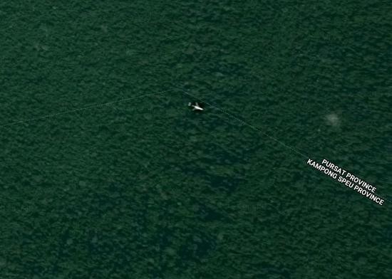
Many netizens searched based on the Google Maps coordinates provided by Wilson (12.089059, 104.151882), and indeed saw the same image.
But is this really MH370, which has been missing for four and a half years? Suspicions abound, and so far there is no conclusive evidence to confirm this claim.

In fact, this is not the first time someone has claimed to have found MH370 on Google Maps.
Off the coast of Padang, Indonesia

According to the British media "Daily Star", in July this year, some netizens posted a screenshot of Google Maps on social networking sites, pointing out that the picture depicted the crashed passenger plane MH370, which crashed off the coast of Padang, Indonesia.
The news quickly spread, and many people believed it to be true. According to Xingzhou.com, Eddie, the head of the Indonesian Padang Disaster Management Committee, then "refuted the rumor", saying that the pictures posted online showed traces of posting productin, and the Indonesian government had never received relevant information.
Near the Round Island of Mauritius

According to Fox News, in March this year, Australian amateur air crash investigator Peter McMahon said that he had carefully studied Google Maps and confirmed that the wreckage of MH370 was located 16 kilometers south of Round Island in Mauritius in the southwestern Indian Ocean. He has given the information to the Australian Transport Safety Bureau (ATSB) and also claims that the fuselage of the plane is full of bullet holes.
A spokesperson for Australia’s Joint Agency Coordination Centre said McMahon contacted the Australian Transport Safety Bureau via Facebook and email in 2016 and 2017, but the date of sending the pictures was November 6, 2009, four years before MH370 disappeared.
South Africa’s Cape Coast

According to the Daily Mail, in March 2016, Scott Waring, editor of the daily UFO sighting newspaper, reported that while searching for UFO sightings on Google Maps, he had accidentally found the wreckage of a plane suspected to be MH370 off the coast of the Cape of Good Hope in South Africa.
Mr. Waring said the satellite photo, taken on June 27, 2015, was 16 months away from the accident, and that it was most likely to have drifted there, based on Australian models of currents that floated MH370. But no debris was found in the area in subsequent searches.
The Operational Secrets Behind Google Maps
Since the disappearance of MH370, almost the whole world has been actively searching, and many ordinary people also want to do their part. Google Maps has become one of the most efficient search tools.
According to British technology media Stuff, Google Maps spokeswoman Susan Cadrecha said that Google occasionally captures some difficult-to-explain images, especially objects moving at high speed underwater, such as fish, water currents, etc., which may form an airplane-like outline and give people the illusion.
However, Google Maps does capture "special effects images" of real aircraft.
A plane appears to have landed on a rooftop in central Adelaide, Australia.


It looks like a plane is parked in the yard of a family in Paraguay.

Forbes reported that Google Maps uses multiple satellite images to map the world, and satellites occasionally capture aircraft in flight, which may give users the above-mentioned bizarre images.
Google Maps’ satellite imagery is sourced from DigitalGlobe, a US commercial space imagery and geospatial content provider, whose Earth Imaging Satellite is capable of capturing 30-centimeter resolution images.

Each of DigitalGlobe’s satellites orbits the Earth 16 times a day and can collect 3 million square kilometers of imagery. Working around the clock, these satellites have long amassed a wealth of data that powers Google Maps.

In addition, Google has hired a special team to manually check and correct maps using an internal program called "Atlas." Operators not only check for problems reported by tens of thousands of users every day, but also fix them as needed.
Google Maps’ "Scientific Open Way"
As well as providing users with navigation, Google Maps has long been a "professional assistant" for explorers and archaeologists.
Google Maps was first used by an Italian programmer to discover historic sites. He discovered an ancient Roman manor more than 2,000 years ago. Since then, Google Maps has become a weapon for many archaeologists.

Last October, archaeologists discovered 400 mysterious stone gates estimated to be 9,000 years old in a remote desert in Saudi Arabia using Google Maps.

David Kennedy, a professor at the University of Western Australia who led the study, said he was contacted by a Saudi doctor with an interest in history who spotted the spectacle on Google Maps. The area is a "hellscape" without vegetation or water, so it has not been explored before.
The high-resolution images are "democratizing" archaeological research, Mr. Kennedy said.
In May of this year, a British butterfly scientist named Julian Bayliss discovered the last "secret garden" on Earth with the help of Google Maps.

According to the technology media The Verge, Belize used Google Maps to observe the African rainforest for 15 years. In 2012, he found a volcano-like mountain range between Mabu and Namuri mountains in northern Mozambique.

After six years of observation and research, Belize led an expedition into this pristine tropical rainforest in northern Mozambique. The reason why it is called the last mysterious garden on earth is because of its steep terrain and 700 meters above the ground, which keeps this rainforest the most pristine ecology.
In fact, ordinary people can also use Google Maps to start their own exploration and archaeological journey. Google Earth also added an "Explorer" tool last year, which contains introductions from experts in various fields to help you rediscover this wonderful world.